
 English
 Magyar
Geotechnics and Societal Implementations
We develop integrated methods combining muon tomography (3D reconstruction), geophysical techniques (e.g. seismic methods), and muographic measurements to determine the physical properties of rock formations and man-made structures. These methods may be suitable for structural geological, mining, and archaeological investigations. The high penetration capability and low scattering of muons enable highly accurate (typically within a few centimetres) positioning in laboratory environments using muon detection. We plan to develop field applications of muon-based positioning techniques (Varga & Tanaka, Sci. Rep. 14, 7605 (2024)) for environments where conventional technologies, such as GPS, have limited applicability or cannot be used at all.Exploring Fracture Zones, Faults and Cavities
The Innovative Detector Development "Momentum" Research Group at the HUN-REN Wigner RCP has been conducting numerous underground muography measurements since the early 2010s. The High-Energy Geophysics Research Group has successfully developed tomographic methods and applied to underground muographic data collected in the Buda Hills and at Esztramos Hill, identifying fracture zones, abandoned mine workings, and cavities. These findings may contribute to the assessment of geological hazards, improving the safety of underground infrastructure, and ensuring the sustainable management of abandoned mines and the subsurface environment.
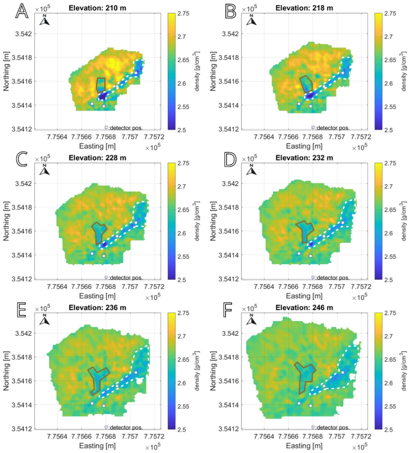
Muon tomographic slices of Esztramos Hill at elevations of 210–246 metres above the detector. The white dashed lines outline the previously known mine tunnels. A new cavity can also be identified within the area delineated by the red line.
Investigating Volcanic Structures and Slopes
Volcanoes can remain unstable for long periods following eruptions, and weakened slopes may collapse, triggering dangerous landslides. We investigated Japan’s Unzen volcano using muography over several months, obtaining a detailed picture of its internal structure without the need for drilling. The results showed that some lava formations have a lower density than the surrounding rocks, which may indicate structural weakening caused by previous eruptions. By comparing the measurements with precipitation data, we found no evidence of rainfall-induced instability during the study period. This research highlights how long-term muon radiographic monitoring can contribute to assessing the stability of volcanic structures and improving the evaluation of landslide hazards.
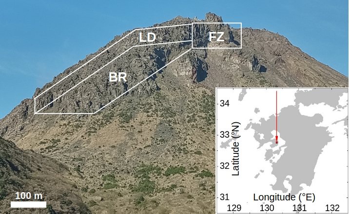
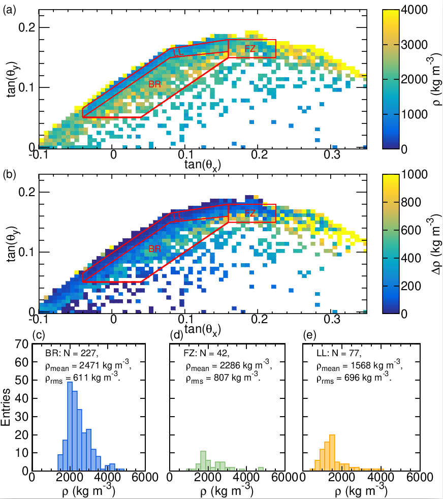
Photo of Mount Unzen (upper) and a high-resolution muographic denity image (lower).
Future R&D Directions
Planned R&D works, projects:
- R&D and application of an integrated müon imaging and positioning system;
- Inspecting and monitoring infrastructures;
- Demonstrating mining applications.
Selected publications
Earlier results:
- Oláh, L., et al. (2023). Földtudományi kutatások és geotechnikai alkalmazások kozmikus müonok mérésével Magyar Geofizika, 63. évf. 4. szám, 225-241.
- Oláh, L., Tanaka, H.K.M., Mori, T., Sakatani, Y., & Varga, D. (2023). Structural health monitoring of sabo check dams with cosmic-ray muography iScience, 26, 108019.
- Balázs, L., et al. (2023). 3-D muographic inversion in the exploration of cavities and low-density fractured zones Geophysical Journal International, 236, 700-710.
- Varga, D., & Tanaka, H.K.M. (2024). Developments of a centimeter-level precise muometric wireless navigation system (MuWNS-V) and its first demonstration using directional information from tracking detectors Sci Rep 14, 7605.
Recent results (2024-):
- Balázs, L., et al. (2025). Detection of fractured zones, faults, and cavities by high resolution muon tomography in the Buda Hills. Sci Rep 15, 17514.
- Rábóczky, B., et al. (2025). Void discovery inside Esztramos Hill using muographic methods. Sci Rep 15, 33394.
- Surányi, G., et al. (2025). Underground muography measurements by the HUN-REN Wigner Research Centre for Physics. J. Appl. Phys. 138, 064903.
- Oláh, L., et al. (2026). Muography for structural characterization of volcanoes: a case study at Mount Unzen, Japan. Geophysical Journal International 244, ggaf482.